Ring Road 2 Elevated Expressway and Vinh Tuy Bridge Phase 2: Infrastructure Transformation and the Urban Value Field
1. Project Overview and System State Shift (2023–2026)
The Ring Road 2 elevated corridor combined with Vinh Tuy Bridge Phase 2 constitutes a core strategic transport infrastructure project in Hanoi, seamlessly connecting the Nga Tu So – Truong Chinh – Dai La – Minh Khai axis with the city's eastern gateway. The project comprises two major components: the Ring Road 2 elevated highway and the Vinh Tuy Phase 2 bridge spanning the Red River.
The official commissioning of Vinh Tuy Bridge Phase 2 in August 2023 finalized the corridor's carrying capacity and closed a vital link in the inner-ring road system. Beyond expanding physical traffic capacity, this integration fundamentally reshaped connectivity between central Hanoi, the eastern urban expansion zone, and the inter-regional transport network.
By 2026, following nearly three years of fully integrated operation, the corridor has transitioned into a steady state. From the perspective of Urban Value Field Economics (UVFE), the network has reached an Inter-regional Flow Equilibrium—a phase where initial infrastructure impacts are fully embedded into the urban spatial structure and progressively reflected in the spatial distribution of land values.
08/2023: Vinh Tuy Bridge Phase 2 Completion → 2024: Traffic Flow Redistribution → 2026: Convergence of Urban Value Field
2. Shifts in Transportation Dynamics and Spatial Development
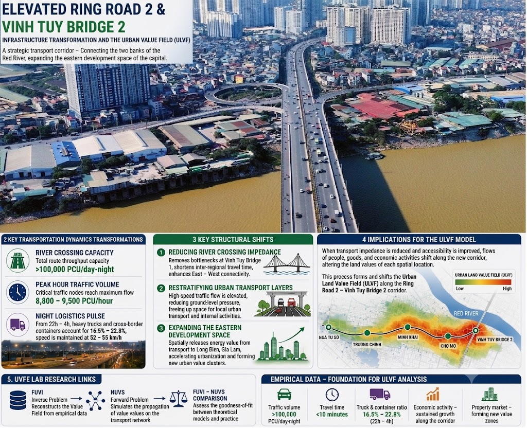
The synchronous operation of Vinh Tuy Bridge Phase 1, Vinh Tuy Bridge Phase 2, and the Ring Road 2 elevated expressway has significantly enhanced cross-river throughput capacity across the Red River while drastically easing congestion at key grade-separated intersections, including Minh Khai, Cho Mo, Dai La, and Nga Tu Vong.
This arterial corridor now functions as a strategic multimodal route accommodating commuter traffic, freight transport, and urban logistics, thereby elevating structural connectivity between central Hanoi, emerging eastern development zones, and national transport networks.
3. Three Core Structural Shifts
First, reduction of river-crossing impedance and enhancement of inter-regional connectivity. The completion of Vinh Tuy Bridge Phase 2 substantially expanded cross-river flow capacity across the Red River, reducing travel times and mitigating traffic bottlenecks on existing bridges.
Second, vertical stratification of the urban transport system. The elevated expressway absorbs high-volume arterial and inter-regional through-traffic, relieving grade-level road networks and improving the overall urban traffic environment.
Third, spatial expansion toward Eastern Hanoi. Enhanced accessibility has driven urban expansion, heightened investment attraction, and catalyzed the emergence of new land value zones along the Ring Road 2 corridor.
4. Implications for the ULVF Model
From the perspective of the Urban Value Research Center (UVRC), traffic throughput capacity, travel time savings, and corridor connectivity are more than engineering metrics—they act as key observable variables reflecting the spatial redistribution of the Urban Land Value Field.
As transport impedance declines and spatial accessibility improves, flows of people, goods, and economic activities realign along these newly established corridors, fundamentally altering the spatial dynamics of urban location attractiveness. This process drives shifts within the Urban Land Value Field (ULVF), providing critical empirical data for the UVFE Lab to validate urban value analytical models and spatial simulations.
References
[1] Prime Minister of Vietnam (2016). Decision No. 519/QD-TTg dated March 31, 2016, approving the Master Plan for Transportation of Hanoi Capital to 2030, with a vision to 2050.
[2] Hanoi Department of Transport (2023). Operational Plan No. 903/PA-SGTVT dated August 29, 2023, on traffic organization via Vinh Tuy Bridge Phase 2.
[3] Hanoi People's Committee (2023). Completion and Technical Traffic Opening Report for Vinh Tuy Bridge Project Phase 2.
[4] Hanoi Department of Transport (2024). Evaluation Report on Traffic Organization Efficiency after One Year of Integrated Operation along the Ring Road 2 Corridor.
[5] Hanoi Transportation Construction Investment Project Management Board (2023). Technical Acceptance Documentation for Vinh Tuy Bridge Project Phase 2.